In a vibrant tapestry of color, music, and collective joy, cultural festivals around the globe offer a spectacular showcase of human tradition, creativity, and unity. Capturing these moments from the ground allows us to see the world as participants, but viewing them from above through drone photography presents an entirely different perspective. It reveals the scale, energy, and beauty of these gatherings in ways previously unimaginable. This blog post delves into the art of documenting global celebrations with drone photography, offering insights into capturing the essence of large-scale events, crowd dynamics, and the vivid details that define these vibrant festivities. The Bird's-Eye View Advantage Drone photography transforms cultural festivals into living mosaics, where every participant becomes a piece of a...
In the face of natural disasters and emergencies, rapid response and accurate information are critical to saving lives and hastening recovery efforts. The advent of drone technology has revolutionized the way we approach disaster response, offering an eye in the sky when it's needed most. This post delves into the transformative role drones play in emergency situations, from surveying damage to aiding in search and rescue operations, and highlights case studies where drone footage has been instrumental in recovery efforts. The Unseen Heroes in Disaster Response Drones, or unmanned aerial vehicles (UAVs), have become invaluable assets in the toolkit of emergency response teams worldwide. With the capability to quickly cover vast areas, drones provide real-time data that is crucial for...
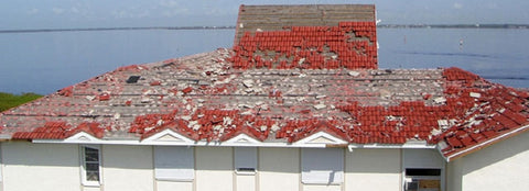
Hawaii is a beautiful and diverse state, with a wide range of landscapes, including scenic beaches, lush forests, and towering mountains. However, with its stunning beauty also comes the risk of natural disasters, such as hurricanes, typhoons, and floods. When these events occur, insurance adjusters in Hawaii face the challenging task of assessing the damage and determining the extent of the loss. Aerial photography can help insurance adjusters in Hawaii overcome these challenges. By using drones equipped with high-resolution cameras, insurance adjusters can get a bird's-eye view of the damage, making it easier and safer to assess the extent of the loss. For example, after a typhoon hit the islands of Hawaii, insurance adjusters used aerial photography to survey the...